This is an introduction of a lesson example using the Geographic System Approach.
I teach geography at a public high school in Japan
Please forgive me for not being able to explain well because I am not an English teacher.
Reference Here is an introduction in Japanese (日本語での紹介はこちらです)
https://geogami.hatenablog.com/entry/2019/10/29/010000
Introducing a geographic system approach
Active learning
I introduced a system approach in my geography lesson
"System Approach lesson in High School (Geography)"
Practical trial report at a high school in Japan
Motive for this lesson development
Examples of global environmental crises and wars of great powers
It is a crisis situation where the conventional order can no longer be reconstructed.
“If we learn about something serious after it happens, we can no longer deal with it.
It is said that the last few years will be the end of a resolution for the global warming problem.
The definition of the way of learning“ change in behavior based on past experience ”has been questioned.
The Global environmental crisis, strong power conflicts, world fragmentation, widening disparity, explosive progress in science and technology, and further challenges. In global problems, “foresight” is needed to learn not only about the past but also for the future.
How can we connect learning to “action”?
For that purpose, partial understanding alone is insufficient.
An understanding of “overall picture” and “structure” is required.
Meta-recognition is required
“Structural understanding” becomes important.

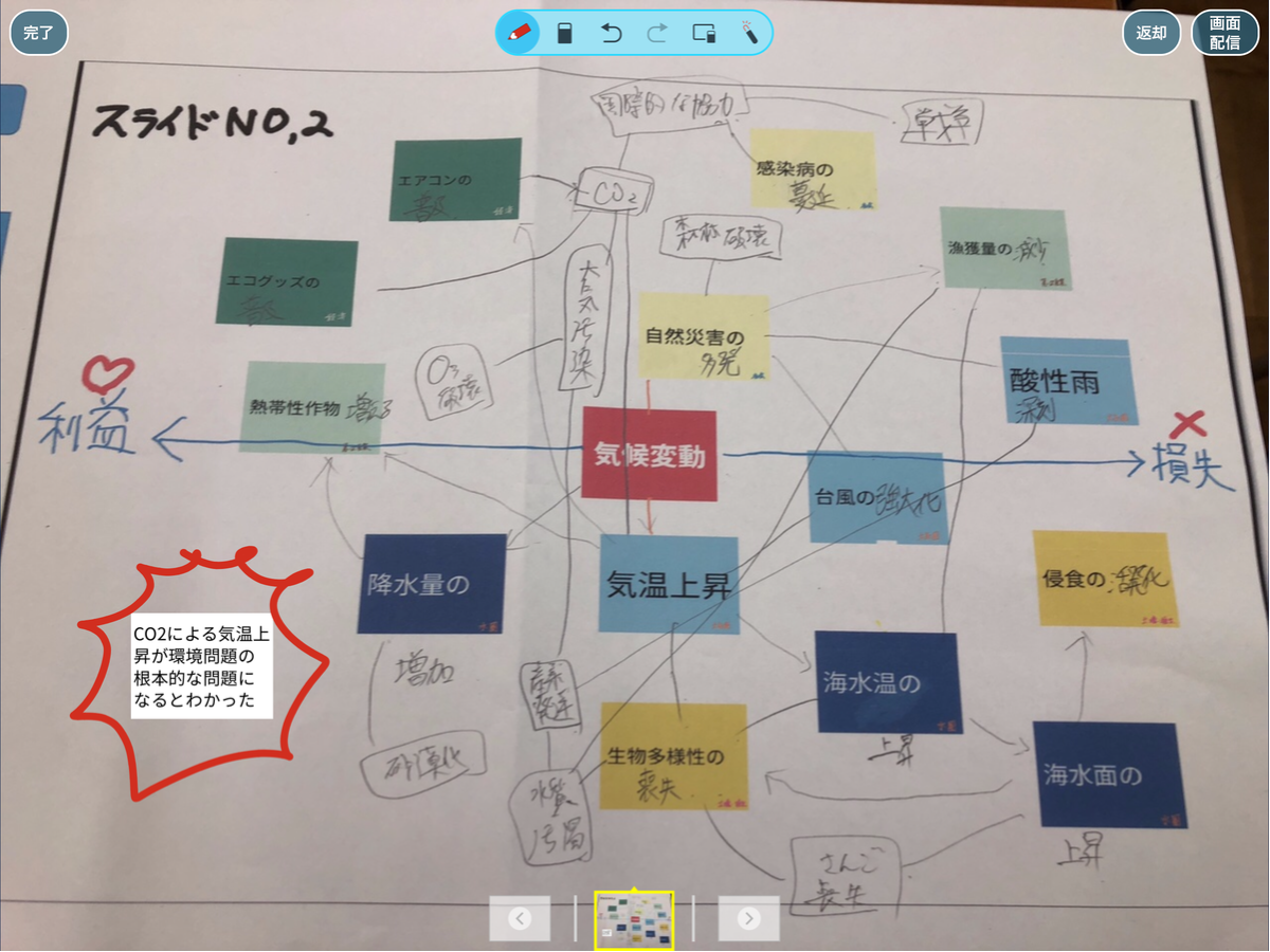
* ↑ A sheet created by each student after class
( Took about 10 minutes during class + time after school)
Student feedback
It was understood that temperature rise due to CO2 etc. would become a fundamental problem of environmental problems.
Hypothesis
”Clarify the“ potential factor ”that“ metacognition ”invites action
and it changes "action" "

* ↑ German textbooks referenced this time
The “system approach” is one of the methods of geography education.
System thinking incorporates the whole concept
It doesn't take the problem as a part
We see the whole structure
After each person has an image,
Search for solutions through dialogue.
In practice toward problem solving, we use “the principle of leverage” to lead to actions that hold points.
(Leverage → A place that leads to deep meaning and improvement with minimal effort)
This seems to have a high affinity with the thoughts of the SDGs promoted by the United Nations.
* Reference: System approach theory
https://geosysapp.jimdo.com/理論編/
・・・・・・・・・・・・・・・・・・・・・・・・・・・・・・・・・・・・・・
About the process of making this lesson
Referring to study groups, academic conferences, and overseas materials
It has been promoted with the image that it can be used in the classroom.
Reference
https://geogami.hatenablog.com/entry/64829385
Https://geogami.hatenablog.com/entry/64607646
Https://geogami.hatenablog.com/entry/64903446
The first thing I felt
Introducing overseas cases directly into Japanese education
I felt it did not fit
There are 40 students in the class
The place is not a special geography classroom
The teacher moves to the Homeroom class.
Limited space of ordinary classrooms
Poor ICT environment
Projector and BYOD smartphone can be used
And
Achieving balance with academic ability and career guarantee that points can be scored in external examinations and entrance examinations
It has become practice but there is not enough time to achieve it properiy.
From a researcher's perspective
It may be pointed out that this practice is imitating and not formal.
But,
The situation surrounding global environmental problems is getting worse every day
Isn't it too late to start after the teaching method is completed?
I tried to take a step as a practical example from the Japanese field.
This time, I focused on the environmental issue of “global warming”
"Rise in global temperature".
・・・・・・・・・・・・・・・・・・・・・・・・・・・・・・・・・・・

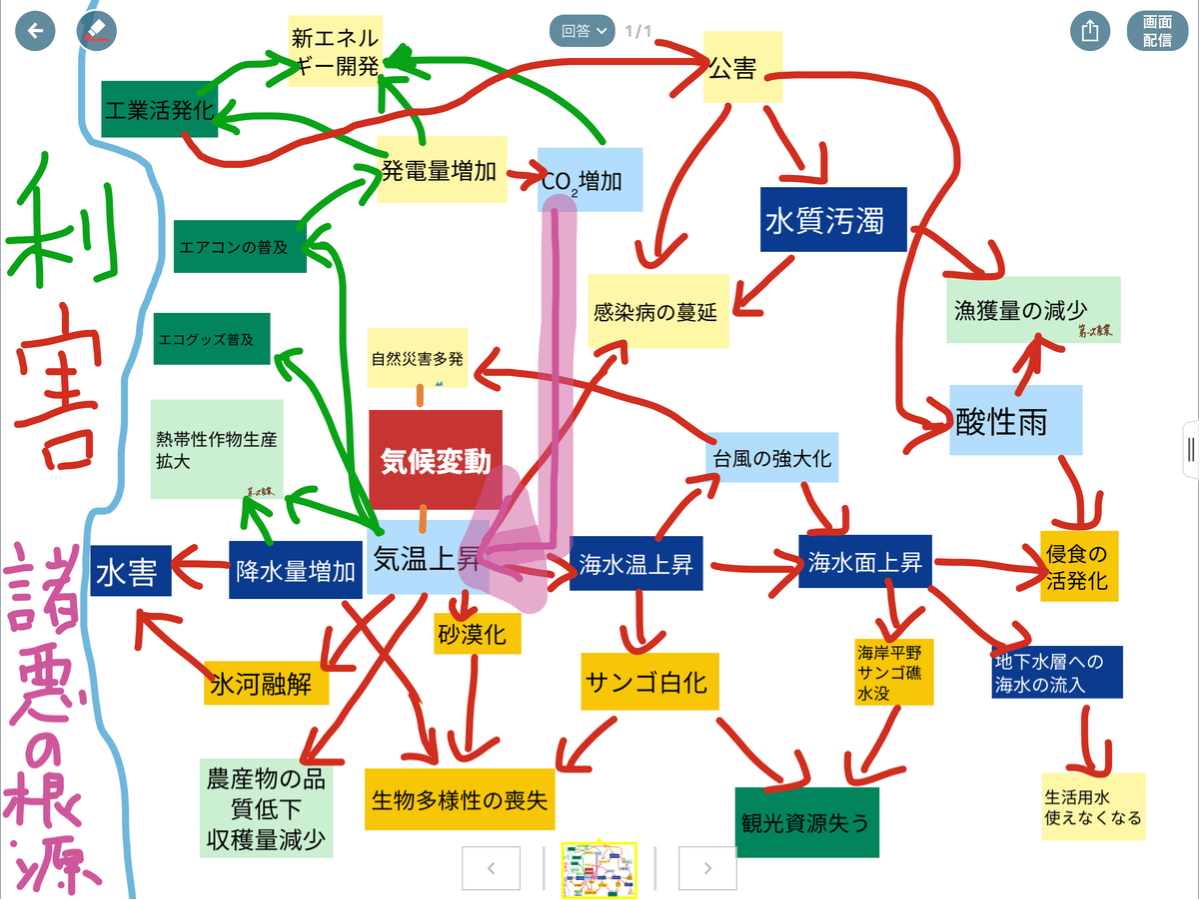
* Worksheet created by each group
Based on this worksheet, students will create a sheet for each person.
Explanation of lesson flow
① Distribute the worksheet (relationship diagram)
Explain the purpose of this lesson.
Explain students that the theme of this lesson is “climate change” → “global warming”. (Description 5 minutes)

* The ↑ sheet is created with the Loilo note for school application.
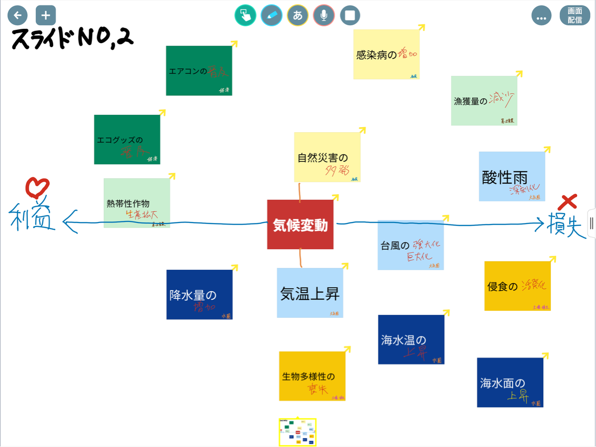
Explanation of relationship structure diagram
“Benefit” on the left side
"Loss" on the right
The upper is human activities such as humanities, society and economy
The lower is a matter related to nature such as soil, hydrosphere, air
I tried using a sinking tool.
About "benefits" and "losses"
Students have already learned about the Japanese natural environment.
Reference "Benefits and losses of nature in Japan" ↓
https://geogami.hatenablog.com/entry/64885871
② The teacher shows the keyword on the card.
Card color varies depending on keyword elements
Elements related to “atmosphere” are light blue
Elements related to “Water Sphere” are blue
“Soil / vegetation” element are “yellow”
The element related to society are the color of lemon
The element related to “primary industry” are light green
Elements related to “economy” are green
However, the element is written on the card, but it does not indicate what happens.
From here, we begin activities as an introduction of activities.
(Such as warming up before a sports game)
First, students say what is happening to each element on the card.
This is to confirm the items already learned
Teachers should show related textbooks, map books, data collections, and notebook pages as hints.
Student activities (5 minutes)
→ Confirm with pair work or group work
Enter what happens for each element
First write by yourself
→ Groups, pairs, individuals, etc.
Students can choose an activity style
→ The last is done individually
Classroom activities (5 minutes)
→ Teacher shows the card using loilo Note as appropriate
Check what happens for each element
The completed figure is shown below. ↓
・・・・・・・・・・・・・・・・・・・・・・・・・・・・・・・・・・・・・・・

③ Go to the next step. (Required time is 15-20 minutes)
Try to connect cards considering the relationship,
You can add more cards as needed.
First think individually, then move on to group work.
Teachers make enlarged poster size copies of worksheets for group work
Teacher should prepare a thick pen for writing.
This “dialogue” is the climax in this lesson.
I think that each group of 4 people is the best
In Japan, 40 students take classes in one class,
Japanese regular classroom space is too small for 40 people !
It would be difficult to secure a place for 10 groups of activities in a regular classroom.
Unfortunately, we have to increase the number of students per group.
There was also a failure!
I did this lesson twice,
The first lesson was・・・
2 groups of 9 people with 18 people who chose geography
The second class failed !
Because there was no place to put a work poster in the 40-person class
For 4 groups of 10 people
At this time it failed because there were too many students.
To do it in a normal classroom, we can make the poster smaller,but
Then we cannot share with all the classrooms.
(I can not see because it is small) → This is the problem
I hope I can use ICT
However Data exchange takes time and does not end in 50 minutes !
No time for the next personal work
It was a compromise product.
The practice that 40 people cannot be deployed in a normal classroom will not spread.

Let's Talk back to student activities
④ Again, the students return to their seats and watch the posters created by each group
Finally, each student starts to create a worksheet. (15 minutes)
Students found it very difficult at the start
Teacher gave a hint's ! For example・・・
Location: What kinds of problems occur at low latitude, middle latitude, and high latitude?
Nature: What are the effects on topography, climate, vegetation, soil, etc.?
Humanities / Economy: Changes in agriculture, forestry and fisheries, trade, politics, population, and inequality?
The teacher also added advice.

⑤ Finally, submit your own worksheet (relationship diagram) !
I give students two choices as a method, both of which utilize loilo Note.
Reference: Click here for an introduction to Loilo Note
There are two methods: taking a photo of the worksheet and submitting it, and using the loilo Note thinking tool.
Consider the introduction in the next class for the deadline for submission
The day before the next lesson day, until 20:30.PM : JST
I would like to recommend the latter if there is room in class development.
In the field, “securing time” is actually the biggest issue for teachers and students.
(Some people submitted them with LoiLoNote, but it seems that the operation on the smartphone was a little cumbersome! )
Check what was submitted as the person in charge
(With red pen and underline)
Set the class to “no name” and share it by sharing the answer.
Japanese students are shy and don't want to name their workseet.
(The teacher keeps students from seeing each other's workseet after making their names unknown.)
3rd grade class → Senior grade
Almost everyone has submitted, but some photos have become vertical!

Added instructions for second-year classes to submit photos sideways.

The class this day was only 45 minutes! due to school events.
About 2/3 of the students had submitted within the deadline.
Some students answered with a loilo Note card.

Reference:Click here for an introduction to Loilo Note
About evaluation evaluation of instructional effectiveness
I do not measure quantitatively
I took a simple qualitative review of the students' impressions.
(Submitted with the worksheet as the second loilo Note card.)

Environmental issues are usually explained one by one !
→ In many cases, it is necessary to understand.
This lesson seems to have the following recognition♡

As a performance evaluation
For “description” of environmental issues and “relationship diagram” on worksheet
Draw new elements such as "new technology development", "international cooperation", "war", "earthquake"
Ask students to ask questions about "warming" using the "relationship structure diagram", etc.
Various ideas are likely to be considered.
If you proceed carefully, you may consider pre-form → post-form evaluation.
Achievement?
What do you know? → What can you do?
”Global warming” causes various problems
Recognizing that this is an important issue that must be resolved
Isn't it deepened?
I think he felt serious.
Was the student able to take a step forward?
Summary / impression
This year's class on “environmental issues” was held only twice.
Because this field deals with citizen, health, home economics
A cross curriculum could also be implemented.
Essential items as a global citizen.
It seems to be interesting even if multiple teachers are implemented in Team Teaching.
Group work can be expanded for 40 people
If you have enough space
10 groups of 4 people are ideal
If you have time
For the overall share, a “poster tour” should be introduced.
This time, we considered “global scale”
German textbooks deal with changes in "Germany"
If it is implemented within the scope of “Japan” or “Local”
It will become more concrete and have a deeper understanding.
I would like to mention at the end that
I tried in a regular classroom / 40 students / 50 minutes.

Thank you for reading to the end !